Cosmogenic-nuclide data related to a paper about surface mobility in the Dry Valleys
The point of this page is to assemble data, photos, observations, relevant to a paper on surface mobility and surface erosion processes in the DV. The overall concept is that there are a lot of examples in which the exposure history of loose surface materials is very different from the exposure history of the substrate. This paper should i) go through these examples, and ii) relate them to the other observations of surface sediment transport, i.e. sediment traps, boulder trails, etc. and so on.
Questions on this page: Greg Balco, balcs@bgc.org
This page covers all the observations for unconsolidated sediment surfaces. All the observations for bedrock surfaces appear on another page.
2. Situations where surface material on unconsolidated deposits has a very different exposure history from that of the substrate.
Basic concept here is that soil pit observations show a number of situations where the exposure history of surface samples is incompatible with the exposure history of the substrate exposed in the soil pit. In some cases this could be the result of erosional lag formation, as is the case for bedrock surfaces. However, many of the observations cannot be explained in this way (mainly because surface clasts are "younger" than the substrate), so a better overall explanation for all data is that there is a mobile surface layer whose lateral transport rate is relatively a lot higher than the degradation rate of the deposits.
The main source of data here is the Ne-21 measurements. This is because I've actually measured Ne-21 in all the surface clast samples that had quartz separation done. In contrast, there aren't any Be-10/Al-26 measurements on any of the clast samples. For a couple of pits (the ash pits) there are Al-Be measurements on the surface sand layer overlying the ash. We have data of this sort for four pits. Then we have similar data for the Hart Ash pit from Al/Be measurements above the ash, but we have no Ne-21 measurements from this pit.
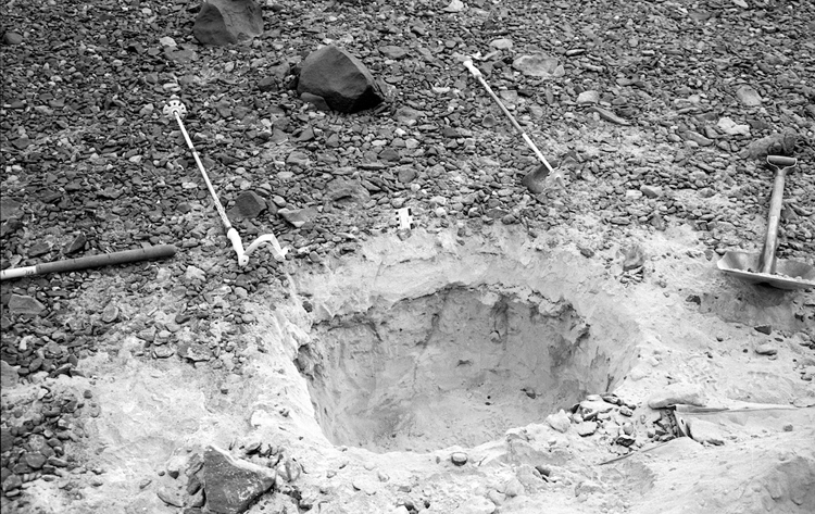
2.A. Pit 4 - Arena ash
Dan has already written about this pit at some length. The pit exposes the Arena Ash above a desert pavement developed on, I think, colluvium. The site is on a moderate slope and a couple of hundred meters above it there are what appear to be active gelifluction lobes. Here is a picture of the pit:
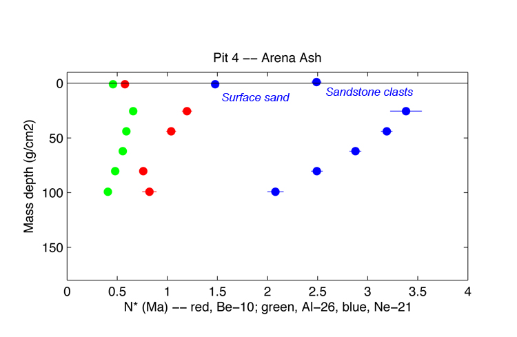
Here are the cosmogenic-nuclide measurements. N* is the nuclide concentration normalized by the surface production rate, which has units of years. This is a simple way of comparing all nuclide concentrations on the same diagram.
As discussed at some length by Dan, the Al-26/Be-10 profiles are consistent with steady erosion at 0.2 m/Myr. Basically, what this means is that they fit an exponential P(z) relationship. The Ne-21 depth profile below the ash is not consistent with this, which indicates that something else happened during Ne-21 time that is not recorded during Al-26 time. However, that's the subject of a different paper.
Important for the present is that Al-26, Be-10, and Ne-21 concentrations in the surface sand layer atop the ash are too low to reflect the same erosion rate as the ash and the substrate. Also, Ne-21 concentrations are too low to have the same exposure history as the substrate beneath the ash as well. What this tells us, not surprisingly, is that the substrate and the surface sand aren't the same stuff. This has to be true, of course, because this stuff must have been transported downhill over the top of the ash deposit to get to where it is currently. For this sample, the Al-26 and Be-10 concentrations agree, i.e. yield the same erosion rate, but the Ne-21 concentration gives a lower erosion rate, i.e. there is inherited Ne-21. This suggests that the sand is derived from a recycled sedimentary deposit rather than steady bedrock erosion.
We also measured Ne-21 only in an agglomerated sample of sandstone surface clasts. This had more Ne-21 than the surface sand sample described above. It has an apparent exposure age of 2.5 Ma and an apparent erosion rate of 0.4 m/Myr. This is younger/higher erosion rate than implied by the nuclide concentrations below the ash.
To summarize all these data, all are consistent with both the surface sand and the surface clasts being derived from a higher-erosion-rate/more active environment than the substrate below the ash, and then being transported laterally to the site. The Ne/Al/Be disequilibrium in the sand sample suggests that the source is a sedimentary deposit rather than a bedrock surface, i.e. this sample is relatively young with respect to Al/Be , but old with respect to Ne-21. Becaus this site lies on a slope, downslope transport of "younger" material over "older" material is plausible.
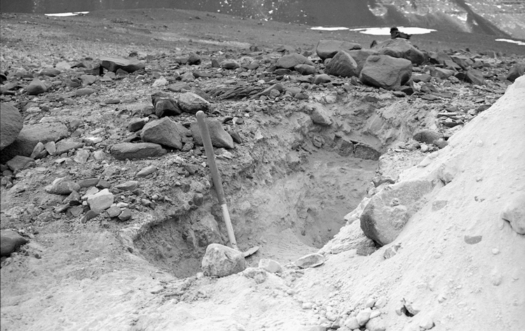
2.B. Pit 6 - Quartermain till overlies Arena till
Dan has also written about this pit at some length. The situation here is that the Quartermain till (> 2.5 Ma) overlies a desert pavement developed on the Arena Till (> 11.3 Ma). This pit lies in a broad flat area in the middle of central Arena Valley. In fact, it is on somewhat of a mound, so there is no obvious source from which sediment could be transported to this site. Here is a picture of the pit:
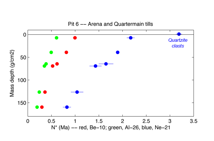
Here are the cosmogenic-nuclide data:
Dan has shown that the subsurface Al and Be data are best explained by a steady-erosion-with-soil-ice-deflation model. I have not yet attempted to determine whether the Ne-21 data are consistent with this model (have to add a couple more parameters for Ne-21 inheritances), but, as noted above, that is for a different paper. We measured Ne-21 alone in an agglomerated sample of quartzite surface cobbles. This lies well above the trend of the subsurface Ne-21 data. The subsurface Ne-21 data (from Q1 till) give an apparent erosion rate near 0.4 m/Ma, whereas the surface clast Ne-21 concentration gives an apparent erosion rate near 0.25 m/Ma.
To summarize, at this site the surface clasts appear to be "older"/lower erosion rate than the subsurface material. This suggests that the cobbles at this site are an erosional lag deposit. Because this site is flat and lies in the middle of a broad basin where there would be no obvious uphill source of surface material to be transported to the site, it makes sense that the surface material is an erosional lag rather than something transported from elsewhere.
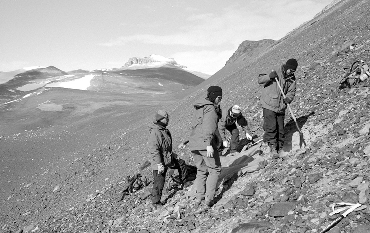
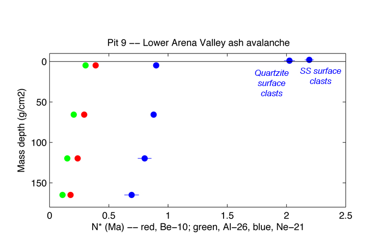
2.C. Pit 9 - Lower Arena Valley ash avalanche
The Putkonen, Balco, Morgan paper in QR is already about the Al-Be concentrations in this pit. Basically, these are consistent with steady surface erosion of the deposit at ca. 1.5-2 m/Myr, plus some inherited Be-10. The pit is on a fairly steep slope. Here is a picture of the pit:
Here are the cosmogenic-nuclide data:
The subsurface Ne-21 concentrations actually don't conform to an exponential profile (most likely because there is some complicated Ne-21 inheritance, which is beyond the scope of this paper). However, it is clear that the surface Ne-21 concentrations are much higher than the subsurface Ne-21 concentrations. The highest subsurface Ne-21 concentration (the sample at 0-2 cm or whatever) has an apparent age of 0.9 Ma/apparent erosion rate of 0.8 m/Myr (this is older/lower than the true age/erosion rate because of an unknown amount of Ne-21 inheritance), the surface sandstone and quartzite clast samples have apparent ages of 2 Ma/ apparent erosion rates of 0.3 m/Myr. To summarize, the surface clasts are much "older" than the subsurface material. Because we know that all of these things contain inherited Ne-21, we could arbitrarily adjust the inherited Ne-21 concentrations to give whatever answer we want, but it still appears most likely that these clasts have been transported to this site from someplace else where the erosion rate is lower than it is at this site. Alternatively, no transport is occurring and these clasts are an erosional lag deposit as we see in the bedrock examples. So these results are a little harder to interpret but again agree with the general concept that the surface layer has a very different exposure history than the subsurface deposit.
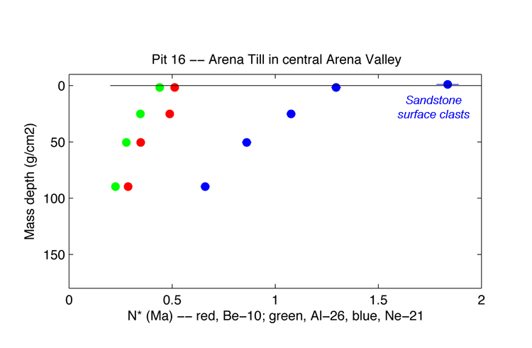
2.D. Pit 16 - Arena Till in central Arena Valley
I don't seem to have a photo of this pit. It's near Pit 6, but dug at a site where the Arena till is the surface unit. Again, it's in a flat area in the middle of the valley. My notes say that there's a ventifact pavement at the surface and the rest consists of Arena till, i.e. light-colored, strongly compacted, sandstone-derived till with faceted clasts.
Here are the cosmogenic-nuclide data:
Dan has looked at this pit at some length and concluded that the best explanation of the subsurface nuclide concentrations was steady erosion at 1.2 m/Myr. The subsurface Ne-21 concentrations also fit an inheritance+exponential model, but even when inheritance is accounted for indicate a much lower erosion rate (ca. 0.6 m/Myr). I am not sure how this can happen, so that's interesting (that goes in the next paper). But regardless, the surface sandstone clasts indicate a lower erosion rate even than that at 0.4 m/Myr. Like Pit 6, this is consistent with erosional lag formation in a flat area where we expect minimal lateral surface transport. So from the surface vs. subsurface perspective, the story here and at Pit 6 are consistent in indicating erosional lag formation during slow erosion of the subsurface.
2.E. Pit 25 - Hart Ash.
We don't have any Ne-21 data from this pit, but as Dan has pointed out the Al-26 concentrations show a surface sample that is "older" than the sub-ash material. This pit is on a bit of a slope.
Summary
To summarize all the pit data, the two pits on flat surfaces show surface material with a much greater exposure age than the subsurface material, suggesting erosional lag formation at these sites. Of the pits that are on slopes, one shows "young" surface material and two show "old" surface material, which is consistent with (and in the "young" case requires) downslope transport of surface clasts from a location where they experienced a different exposure history.